


SAMHSA records as of November 16, 2026
How far is treatment from each Minnesota county?
Method: 87 counties in Minnesota, each measured from its center; miles to the nearest facility of three kinds: detox, live-in program, medicine clinic. Detox more than 30 miles away: 58 counties, population 1,311,052. Counties with no treatment site of any kind: 27.
Useful on the call: an insurance card and a ZIP code, whether the call is for yourself or for someone else. This number: paid referral line, answered by a partner that runs none of the programs in this directory.
All 87 counties
Order: distance to the nearest detox. Distances are straight-line; road miles run longer.
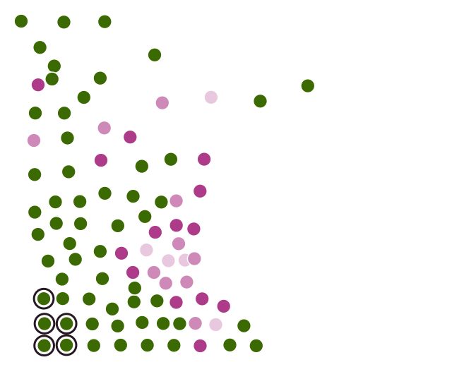
- up to 10 mi 5
- 10–20 mi 10
- 20–30 mi 14
- over 30 mi 58
- Farthest: Rock 150 mi, Pipestone 135 mi, Nobles 132 mi, Lincoln 122 mi, Murray 115 mi
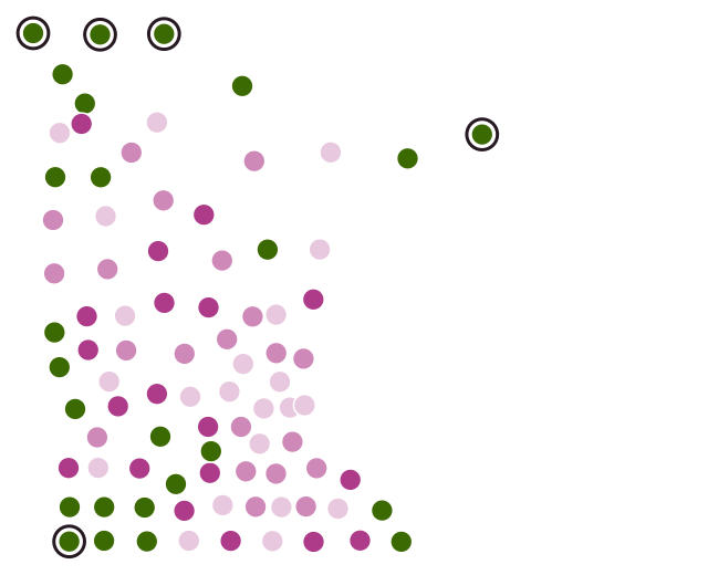
- up to 10 mi 22
- 10–20 mi 21
- 20–30 mi 19
- over 30 mi 25
- Farthest: Cook 100 mi, Roseau 74 mi, Lake of the Woods 61 mi, Rock 59 mi, Kittson 59 mi
| County | Population 2024 | Facilities (county) | Detox, mi | Residential, mi | MAT, mi |
|---|---|---|---|---|---|
| Rock County | 9,525 | 1 | 149.6 | 59.3 | 90.7 |
| Pipestone County | 9,100 | 0 | 134.8 | 38.6 | 70.3 |
| Nobles County | 21,969 | 0 | 131.5 | 53.5 | 65.8 |
| Lincoln County | 5,564 | 0 | 122.4 | 24.9 | 46.8 |
| Murray County | 8,044 | 0 | 115.1 | 30.2 | 64.6 |
| Jackson County | 9,861 | 0 | 113.6 | 35.5 | 35.1 |
| Lake of the Woods County | 3,797 | 0 | 111.9 | 61.4 | 73.8 |
| Lac qui Parle County | 6,636 | 0 | 108.2 | 36.4 | 22.9 |
| Lyon County | 25,577 | 2 | 103.4 | 4.8 | 38.1 |
| Big Stone County | 5,067 | 0 | 101.8 | 40.0 | 46.5 |
| Cook County | 5,571 | 0 | 100.0 | 100.0 | 100.0 |
| Martin County | 19,561 | 3 | 97.0 | 5.5 | 5.0 |
| Yellow Medicine County | 9,373 | 0 | 96.3 | 18.8 | 18.1 |
| Stevens County | 9,819 | 0 | 95.4 | 26.9 | 34.8 |
| Cottonwood County | 11,338 | 1 | 95.2 | 42.2 | 43.5 |
| Swift County | 9,666 | 1 | 85.2 | 6.0 | 22.2 |
| Watonwan County | 11,204 | 0 | 82.6 | 23.4 | 22.7 |
| Pope County | 11,495 | 0 | 80.2 | 19.5 | 19.1 |
| Redwood County | 15,254 | 2 | 78.7 | 25.7 | 43.4 |
| Roseau County | 15,265 | 0 | 78.5 | 73.8 | 47.5 |
| Chippewa County | 12,299 | 2 | 78.2 | 20.5 | 8.3 |
| Traverse County | 3,134 | 0 | 77.3 | 40.2 | 40.2 |
| Faribault County | 13,886 | 0 | 77.2 | 24.6 | 24.6 |
| Grant County | 6,109 | 0 | 73.8 | 24.7 | 25.8 |
| Douglas County | 39,933 | 4 | 73.7 | 5.0 | 6.4 |
| Koochiching County | 11,594 | 3 | 72.0 | 58.1 | 51.6 |
| Brown County | 25,710 | 1 | 68.9 | 37.5 | 38.1 |
| Beltrami County | 46,762 | 8 | 65.8 | 4.2 | 25.1 |
| Blue Earth County | 70,700 | 8 | 62.7 | 6.5 | 10.4 |
| Morrison County | 34,520 | 2 | 61.8 | 23.8 | 21.7 |
| Todd County | 25,955 | 1 | 59.6 | 26.7 | 27.1 |
| Kittson County | 3,992 | 0 | 58.8 | 58.8 | 53.2 |
| Houston County | 18,352 | 1 | 55.3 | 54.1 | 2.4 |
| Renville County | 14,453 | 1 | 54.4 | 35.9 | 27.1 |
| Otter Tail County | 60,884 | 3 | 53.1 | 19.2 | 20.6 |
| Waseca County | 18,684 | 0 | 52.2 | 18.1 | 18.0 |
| Nicollet County | 34,493 | 2 | 51.7 | 20.1 | 18.9 |
| Mahnomen County | 5,296 | 0 | 51.1 | 35.3 | 35.3 |
| Kandiyohi County | 44,674 | 6 | 51.0 | 24.1 | 3.2 |
| Freeborn County | 30,314 | 4 | 50.1 | 1.9 | 0.6 |
| Lake County | 10,698 | 1 | 50.1 | 50.1 | 50.1 |
| Clearwater County | 8,630 | 1 | 49.9 | 18.0 | 18.0 |
| Crow Wing County | 68,642 | 7 | 49.4 | 11.0 | 11.0 |
| Stearns County | 163,997 | 14 | 45.5 | 19.3 | 20.5 |
| Pennington County | 13,652 | 1 | 45.3 | 32.2 | 7.3 |
| Benton County | 41,881 | 1 | 43.0 | 10.5 | 12.4 |
| Aitkin County | 16,335 | 0 | 42.8 | 37.6 | 36.7 |
| Red Lake County | 3,882 | 0 | 42.4 | 23.9 | 17.9 |
| Marshall County | 8,771 | 0 | 41.6 | 41.4 | 18.9 |
| Becker County | 35,444 | 2 | 39.9 | 9.3 | 9.3 |
| Wilkin County | 6,268 | 1 | 37.5 | 17.7 | 17.7 |
| Sibley County | 15,194 | 0 | 37.2 | 31.7 | 22.8 |
| Steele County | 37,434 | 4 | 36.6 | 2.9 | 6.8 |
| Winona County | 49,973 | 3 | 35.3 | 34.6 | 27.8 |
| Le Sueur County | 29,458 | 1 | 34.1 | 17.7 | 17.7 |
| Norman County | 6,284 | 0 | 33.8 | 31.9 | 33.8 |
| Fillmore County | 21,502 | 0 | 31.7 | 30.0 | 28.6 |
| Mille Lacs County | 27,577 | 4 | 30.8 | 16.8 | 11.9 |
| Carlton County | 36,745 | 6 | 29.9 | 6.0 | 6.0 |
| Polk County | 30,413 | 4 | 29.9 | 8.7 | 25.7 |
| Mower County | 40,900 | 3 | 29.4 | 28.0 | 9.0 |
| Meeker County | 23,491 | 2 | 27.7 | 1.3 | 17.8 |
| Goodhue County | 47,982 | 2 | 27.6 | 11.2 | 24.9 |
| Sherburne County | 103,059 | 5 | 27.5 | 8.9 | 8.9 |
| Rice County | 69,025 | 4 | 26.7 | 17.0 | 4.2 |
| Cass County | 31,442 | 3 | 26.5 | 26.5 | 26.5 |
| Isanti County | 43,687 | 2 | 24.8 | 14.4 | 4.0 |
| Chisago County | 59,105 | 3 | 24.7 | 10.1 | 16.1 |
| Wadena County | 14,437 | 1 | 24.1 | 24.1 | 24.1 |
| McLeod County | 36,780 | 2 | 23.4 | 20.8 | 6.7 |
| Wabasha County | 21,574 | 0 | 21.1 | 21.1 | 19.9 |
| Pine County | 30,319 | 3 | 20.5 | 20.5 | 5.4 |
| Carver County | 112,628 | 6 | 19.6 | 10.1 | 10.1 |
| Itasca County | 45,442 | 9 | 19.3 | 19.0 | 10.3 |
| Dodge County | 21,242 | 1 | 19.2 | 18.1 | 19.2 |
| Kanabec County | 16,608 | 1 | 15.6 | 6.2 | 6.2 |
| Washington County | 283,960 | 16 | 14.9 | 4.3 | 3.0 |
| Scott County | 157,206 | 5 | 14.7 | 9.1 | 9.9 |
| Anoka County | 376,840 | 20 | 13.8 | 5.6 | 5.6 |
| Hubbard County | 22,050 | 2 | 11.5 | 11.5 | 11.5 |
| Clay County | 66,848 | 5 | 11.3 | 11.3 | 11.3 |
| Dakota County | 453,156 | 16 | 10.7 | 10.2 | 10.7 |
| Wright County | 154,593 | 11 | 6.6 | 6.6 | 6.6 |
| Ramsey County | 542,015 | 42 | 5.4 | 2.2 | 0.5 |
| Olmsted County | 166,424 | 16 | 4.7 | 3.3 | 2.3 |
| Hennepin County | 1,273,334 | 80 | 2.7 | 2.6 | 1.4 |
| St. Louis County | 200,794 | 28 | 2.1 | 2.1 | 2.1 |
No clear starting point?
Program fit unclear? Any listed program takes direct contact; the referral line below is a second route.
This number: paid referral line, answered by a partner that runs none of the programs in this directory.
Method
Facilities: Minnesota listings in SAMHSA FindTreatment.gov flagged for substance use treatment or detox. Snapshot taken November 16, 2026. County centers: Gazetteer files, U.S. Census Bureau, 2024. Population: Census Bureau estimates, 2024. County assignment: by the facility's ZIP code (Census ZCTA to county file). Distance: great-circle miles, origin at the county's internal point, endpoint at the facility's listed coordinates; for SAMHSA listings lacking coordinates, the Census Geocoder locates the address, and the ZIP code center is used when no street is published. MAT includes certified opioid treatment programs (OTP). Reuse of the data is permitted with a link to this page.